Esri - Tweet Data Analysis
Tweets Analysis - Keyword: @Esri
Resume
Tweets covering
9 days
Latest tweet was on
2023-03-30
Earliest tweet was on
2023-03-21
Total number of tweets analysed
348
Average age of authors' accounts
9 years
Resume
There are various tweets about Esri, a company specializing in Geographic Information Systems (GIS) technology. Some tweets highlight Esri's accomplishments, such as receiving awards for outstanding work with GIS technology and collaborating with other companies. Other tweets cover how Esri's GIS technology can be used in different fields, such as disaster response, conservation, and business education. There are also tweets about events and webinars hosted by Esri.
Modelisation des Sujets
- Recognition and achievement in GIS
- Recruiting and partnerships
- Funding for space imagery and AI mapping technology
- Education and workshops on GIS and conservation
- Application of GIS in various industries, such as sustainability, disaster response, and aviation
Analyse des Sentiments
Analyse des Tendances
- '#GIS is everywhere!' tweeted by @Esri, indicating the widespread adoption of GIS technology.
- Partnerships and collaborations: @Esri partnering with IBM and investing in a startup in order to incorporate GIS technology into sustainability solutions and improve mapping accuracy.
- Promotion of Esri events and exhibits, such as the User Conference, AAG Annual Meeting, and SXSW panel.
- Use of GIS in conservation and environmental efforts, highlighted by @ESAHub and @mongabay.
- Education and certification in GIS through resources provided by @EsriTraining and @gised.
Avertissement : L'analyse de texte de twtdata.com utilise OpenAI et ne represente pas les opinions de twtdata.com ou de ses affilies. L'analyse est uniquement a titre informatif et ne constitue pas une approbation d'une quelconque opinion.
Types de Tweets
Number of Retweets
104
29% du total
Number of Original tweets
113
32% du total
Number of tweets that were Quotes
19
5% du total
Number of tweets that were Replies
122
35% du total
Number of tweets that contain Hashtags
168
48% du total
Number of tweets that contain Mentions
348
100% du total
Appareils Utilises pour Tweeter
Top 5 Appareils
| Source | Count |
|---|---|
| Twitter Web App | 125 |
| Twitter for iPhone | 85 |
| Twitter for Android | 59 |
| Hootsuite Inc. | 26 |
| TweetDeck | 12 |
Repartition des Appareils

Top 10 Comptes par Abonnes
| Username | Name | Bio | Followers count |
|---|---|---|---|
| IBMWatson | IBM Watson | Watson is AI for smarter business, built on language, automation, and trust. | 268 602 |
| Esri | Esri | Esri builds #ArcGIS, the leading location intelligence and spatial analytics software for mapping, 3D GIS, imagery, and geospatial app development. | 192 751 |
| flightaware | FlightAware | The world’s largest flight tracking data company. Founded by #avgeeks and #bigdata nerds to support optimization and reliability in the aviation industry. | 81 060 |
| GlobalLF | Global Landscapes Forum (GLF) | World's largest knowledge-led platform on sustainable land use. Connect, share, learn, act. #ThinkLandscape @GlobalLF_Esp @GlobalLF_FR | 62 772 |
| RGS_IBG | Royal Geographical Society (with IBG) | We are the UK's learned society and professional body for geography, supporting geography and geographers across the world. | 62 134 |
| databricks | Databricks | Databricks is the lakehouse company, helping data teams solve the world’s toughest problems. | 56 592 |
| ICEYEfi | ICEYE | We manufacture and operate the world's largest SAR satellite constellation 🛰️ | 44 063 |
| EsriUC | Esri User Conference | Join us for the world's largest GIS event, July 10–14, 2023! #EsriUC2023 | 36 563 |
| EsriTraining | Esri Training | Advancing geospatial capabilities of individuals, teams, and organizations is our mission and our passion. | 30 239 |
| ArcGISStoryMaps | ArcGIS StoryMaps | ArcGIS StoryMaps helps you tell remarkable stories with custom maps that inform and inspire. Join our growing storytelling community. | 29 942 |
Top 10 Comptes par Abonnements
| Username | Name | Bio | Followers count |
|---|---|---|---|
| Esri | Esri | Esri builds #ArcGIS, the leading location intelligence and spatial analytics software for mapping, 3D GIS, imagery, and geospatial app development. | 72 169 |
| EsriUC | Esri User Conference | Join us for the world's largest GIS event, July 10–14, 2023! #EsriUC2023 | 11 880 |
| barkflight | Cascadia Fire Has No Season | Reporter @watchdutyapp. Incident tweets are unofficial + not emergency advice | Tweets/hatred of onions my own | Say hello: sekhar@watchduty.org | 11 270 |
| Steven_Ramage | Steven Ramage | Wrapping up 6.5 years at the GEO Secretariat, my new business Réseau will be fully operational from 3 April 2023! Still mentoring. | 11 120 |
| Colin_Hung | Colin Hung | CMO & Editor @HealthcareScene. Healthcare Advisor @ventureLABca @Haltech_RIC Co-founder #hcldr. #HealthIT true believer #pinksocks #HITMC #TheWalkingGallery | 10 879 |
| Esri_Conserv | Esri Conservation | Official Twitter account of the Esri Conservation Team. Sharing the exemplary work of the global conservation community leveraging ArcGIS to save our planet. | 9 627 |
| EsriStartups | Esri Startup Program | Growing #Startups. Official #Esri Startup Program Account. Check out our site for program details. Follow the buzz @EsriStartups | 9 428 |
| BzGEO | 🇧🇿 Belize GEO 🛰️ | Belize GEO: Belize Group on #EarthObservation & GIS. #SciComm re: EO, GIS relevant to #Belize, the #Caribbean. Administered by a real live Belizean scientist. | 7 171 |
| Linda__Stevens | Linda Stevens 🌎🌻 | Geographer. Earth champion. CMO. Tech, Healthcare, Geospatial, GIS https://t.co/pDzpTkW8Zd… | 6 684 |
| CesiumJS | Cesium | The Platform for 3D Geospatial. Tile, visualize, contextualize, and analyze your 3D data. #3DTiles #WebGL | 6 316 |
Utilisateurs les Plus Actifs
| Username | Bio | Number of tweets |
|---|---|---|
| geospatial_py | A Twitter bot that automatically retweets everything about #geospatial #python stuff. #geopython #GIS #RemoteSensing #Jupyter. Account managed by @giswqs | 12 |
| GIS_Bandit | Product Manager @Esri | Interests #GIS, #HealthGIS, #Maps, #DataViz Mastodon: https://t.co/BmfMZVb0CI Comments are my own. | 10 |
| josephkerski | Geography, geo-geekiness, STEM, ed tech, space, place, geographic information systems (GIS), GPS, outdoor education 365 days a year. | 8 |
| pokateo_ | 👋🏻 I'm Kate ᵉᵃᵗᵉʳ ᵒᶠ ᵖᵒᵗᵃᵗᵒᵉˢ ᵃⁿᵈ ᵐᵃᵏᵉʳ ᵒᶠ ᵐᵃᵖˢ 🌐 I make #geospatial & #GIS (more) fun by sharing #mappymeme s & #maptastic themes. Hosts #GISchat. ᵛᶦᵉʷˢᵐᶦⁿᵉ | 7 |
| gischatbot | A friendly bot from the GIS community! Check my TL for an interesting #gischat convo. and related GIS kinds of stuff! Developers: @jeafreezy & @adiguntoba | 6 |
| EsriTraining | Advancing geospatial capabilities of individuals, teams, and organizations is our mission and our passion. | 5 |
| esricanada | Esri Canada provides geographic information system(GIS) solutions that empower people to make informed decisions using the power of mapping & spatial analytics. | 5 |
| GISChitterChat | GIS chitter chattery chat. | 4 |
| ImpactObserv | Impact Observatory empowers global decision makers with the AI-powered monitoring solutions they need to succeed. Also now @impactobservatory@fosstodon.org | 4 |
| GD3Duk | #3D #GIS #CityEngine consultancy services from @garsdaledesign, the first 3D content providers on the #ArcGIS #Marketplace & release ready! #geodesign | 4 |
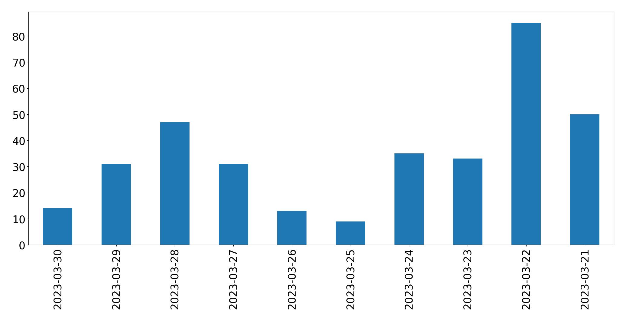
Tweets par Jour
Top 10 Tweets par Retweets
| ID | Text | Retweet count |
|---|---|---|
| 1638495139231399938 | Our partners at @Esri shared with us today on how to preserve biodiversity with GIS so as to achieve sustainable conservation with the power of geography. #ESAHub #RRH https://t.co/XpohMgiHVY | 21 |
| 1638906428134965253 | .@Esri and IBM announce expanded partnership to incorporate GIS technology into #sustainability solutions to inform predictive sustainability in supply chain, facility management and energy consumption: https://t.co/1Z37HZxuIV https://t.co/QTtCqlTuFK | 11 |
| 1638519204264411138 | During today's live session, Pauline Okeyo from @Esri presented on using #DEAfrica imagery to reveal patterns and risks through change detection. Esri are making the DE Africa data accessible to … | 7 |
| 1641063909925744641 | We’re thrilled to announce our Seed funding round has closed at over $5.9M, including an investment by @esri. This will accelerate our work using space imagery 🛰️ + deep learning … | 7 |
| 1638530758858899458 | @DEarthAfrica @Esri @angelaaxis @AFRIGIST_ @AgrhymetInfos @JosephTUYISHIMI @AfricaGeoPortal @DEarthAfrica live session: Using DE Africa imagery to reveal patterns and risks in Africa through change detection (English) – 22 March and recording: … | 7 |
| 1638440372597579776 | 🚨🚨🚨New project alert‼️🚨🚨🚨 @InsideNatGeo just published their #WorldWaterMap, a project with @UniUtrecht and @Esri —and our team at @fndViT, and @SIGTE_UdG. Check out the delicate balance between our water supply … | 6 |
| 1640704421691797504 | In 1 week, @Esri webinar: Enhance #Environmental #Health #Practices with #GIS https://t.co/CAPLS0lF2Q #healthGIS #location #spatial #intelligence #GIS #esri #arcgis #mapping #geospatial @Esri_Health @EsriFederalGovt @EsriSLGov @ArcGISanalysis @EsriPartners https://t.co/BWBkhrA02v | 6 |
| 1641107996531908608 | Looking to gain an Esri certification to support your #conservation work? Explore our certification exams that validate expertise in a variety of Esri #GIS and #Mapping products & capabilities: https://t.co/IqYZkR4Zys … | 6 |
| 1638281026383368218 | I am SUPER excited to share that my GIS team @MichiganEGLE has been selected by @Esri to receive the Special Achievement in GIS Award, which recognizes "outstanding work with GIS … | 5 |
| 1640007951615397889 | @Esri's new online Health #GIS curriculum, advised by CrisisReady co-director @simulacrandrew, empowers #publichealth stakeholders with modern #geospatial skills. Explore the curriculum: https://t.co/Yc0RAJbydV | 5 |
Top 10 Tweets par J'aime
| ID | Text | Like count |
|---|---|---|
| 1638281026383368218 | I am SUPER excited to share that my GIS team @MichiganEGLE has been selected by @Esri to receive the Special Achievement in GIS Award, which recognizes "outstanding work with GIS … | 383 |
| 1638925637946572803 | #GIS is everywhere! @Esri is recruiting at #NSBE49 https://t.co/mRglPJ0LMy | 36 |
| 1638906428134965253 | .@Esri and IBM announce expanded partnership to incorporate GIS technology into #sustainability solutions to inform predictive sustainability in supply chain, facility management and energy consumption: https://t.co/1Z37HZxuIV https://t.co/QTtCqlTuFK | 32 |
| 1641063909925744641 | We’re thrilled to announce our Seed funding round has closed at over $5.9M, including an investment by @esri. This will accelerate our work using space imagery 🛰️ + deep learning … | 30 |
| 1640728684632965121 | Had wondrous and mappy time in this @esri workshop with all the attendees at @theAAG the AAG Annual Meeting! @ArcGISStoryMaps https://t.co/8o77YypaMX | 29 |
| 1638495139231399938 | Our partners at @Esri shared with us today on how to preserve biodiversity with GIS so as to achieve sustainable conservation with the power of geography. #ESAHub #RRH https://t.co/XpohMgiHVY | 28 |
| 1639207620564205570 | The climate stats I find most interesting aren't in the IPCC report. Instead they are that the @Esri found 70% of Irish people are worried about climate change and the … | 26 |
| 1638519204264411138 | During today's live session, Pauline Okeyo from @Esri presented on using #DEAfrica imagery to reveal patterns and risks through change detection. Esri are making the DE Africa data accessible to … | 23 |
| 1640403831098949636 | Had the chance to speak about #youthmappers’ chapters in Ghana and Africa as a whole and also made a plea with @USAID and @Esri to involve @youthmappers in research activities … | 21 |
| 1639252541971259393 | Hope to see you today at the Esri exhibit at the AAG annual meeting. @theAAG @esri we will also have some in-exhibit short demos ! https://t.co/RkNR6PXT6v | 17 |
Principales Langues Utilisees

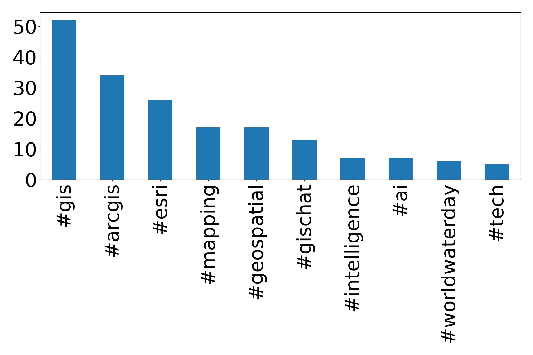
Top 10 Hashtags
| Hashtag | Count |
|---|---|
| #gis | 52 |
| #arcgis | 34 |
| #esri | 26 |
| #mapping | 17 |
| #geospatial | 17 |
| #gischat | 13 |
| #intelligence | 7 |
| #ai | 7 |
| #worldwaterday | 6 |
| #tech | 5 |
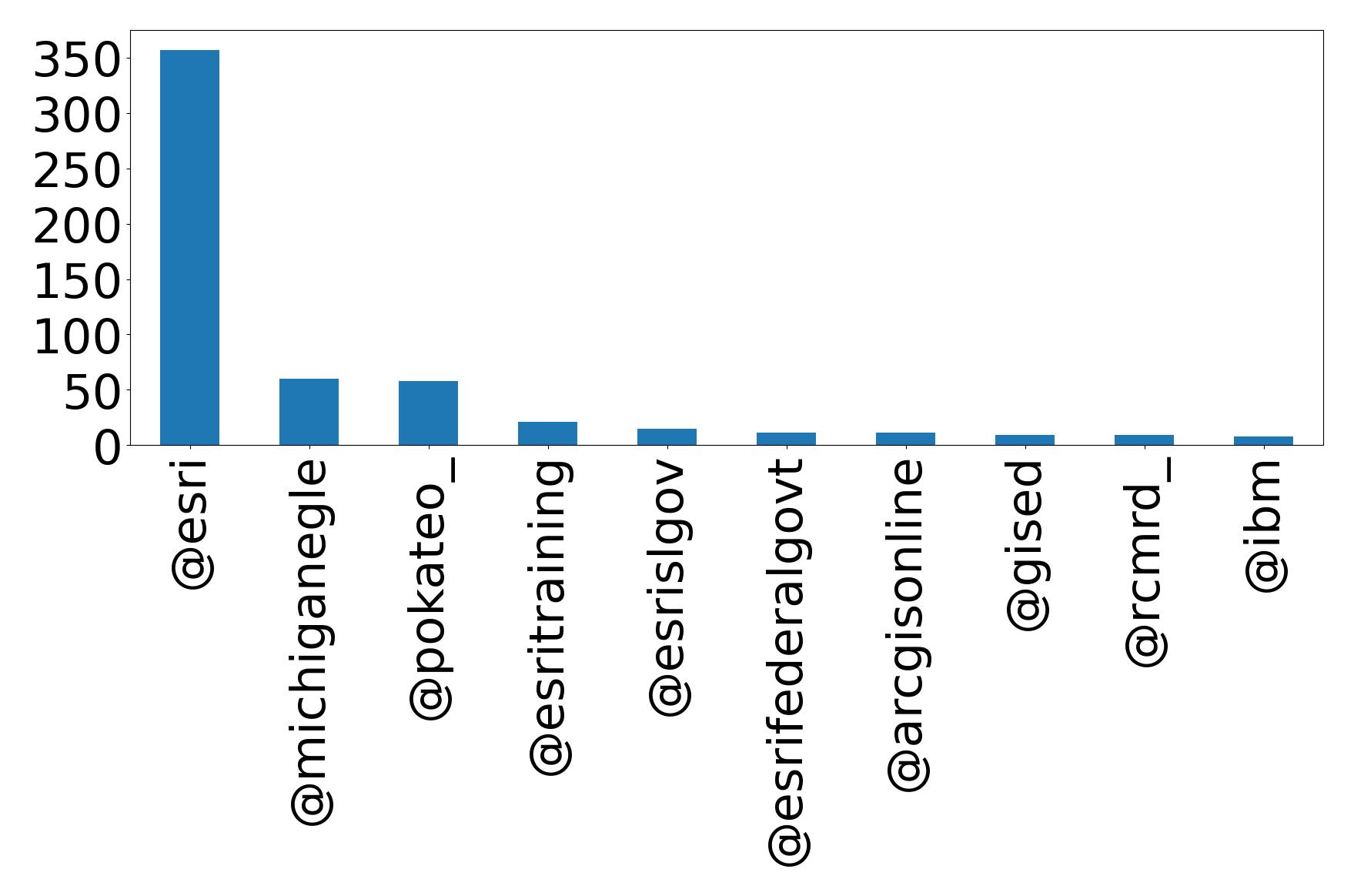
Top 10 Mentions
| Mention | Count |
|---|---|
| @esri | 357 |
| @michiganegle | 60 |
| @pokateo_ | 58 |
| @esritraining | 21 |
| @esrislgov | 15 |
| @esrifederalgovt | 11 |
| @arcgisonline | 11 |
| @gised | 9 |
| @rcmrd_ | 9 |
| @ibm | 8 |
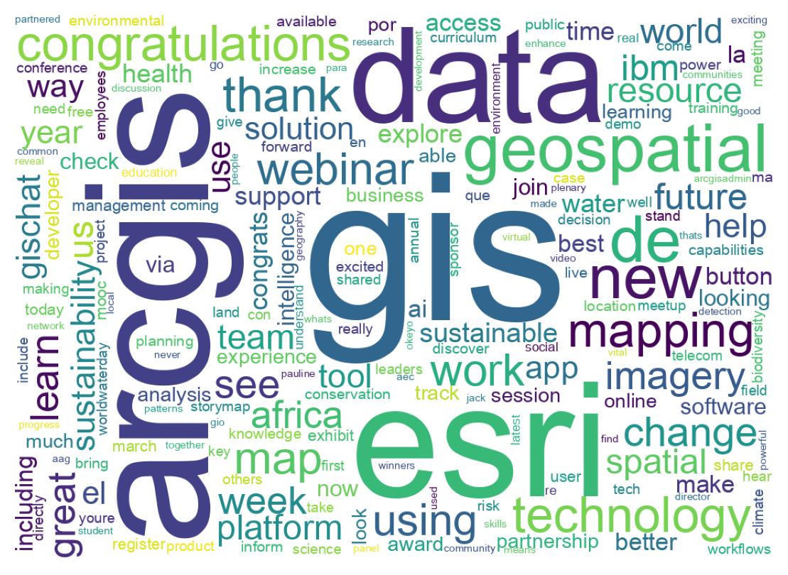
Nuage de Mots des Tweets
Analyse des Emojis
Moyenne d'emojis par tweet :
35
Emojis Utilises
| Emoji | Count | Emoji Text |
|---|---|---|
| 🚨 | 12 | police_car_light |
| 👏 | 9 | clapping_hands |
| 🌎 | 6 | globe_showing_Americas |
| 😂 | 6 | face_with_tears_of_joy |
| 🎉 | 5 | party_popper |
| 🙏 | 4 | folded_hands |
| 🏅 | 3 | sports_medal |
| 🛰️ | 3 | satellite |
| 🔸 | 3 | small_orange_diamond |
| 💧 | 3 | droplet |
Groupes d'Emojis
| Emoji Group | Count |
|---|---|
| Travel & Places | 41 |
| Smileys & Emotion | 25 |
| Symbols | 17 |
| People & Body | 17 |
| Activities | 12 |
| Objects | 5 |
| Food & Drink | 3 |
| Flags | 2 |
| Animals & Nature | 1 |
Besoin d'une Analyse Personnalisee de Donnees Twitter ?
Obtenez des informations detaillees sur n'importe quel mot-cle, hashtag ou compte sur twtData.
Commencer